Level Crossing Upgrade Programme For Wairarapa Line
Kiwirail and Waka Kotahi are working on a programme of level crossing upgrades in the Wairarapa at the present time. At the time of writing this post some difficulty was experienced in determining actually which Government policy announcement covers the level crossing upgrade programme but it appears to date from the announcement of the Wellington Metro Upgrade Programme in October 2018. Various sources have stated that there are 30 public level crossings in the Wairarapa so one of the functions of this article is to document all 30 of those crossings. So far TSBNZ’s requests to Kiwirail for safety and other information on these crossings have been ignored however. This information is important because consultation has started with Wairarapa residents and they are being told that various crossings (which seems to be a large number of crossings across Wairarapa so far) are being considered for closure. Due to the lack of information, the purpose of this post is to examine all those crossings and determine whether the design of any of them is dangerous. TSBNZ will try from other public sources of information to work out whether crossings are dangerous or not but this is not very accurate or helpful, so the fallback is looking at the design features, traffic volumes and any warning devices provided. Crossings are in order of their track distance.
The information is mainly compiled from Kiwirail’s ALCAM level crossing viewer website. Daily figures shown are averages.
Name
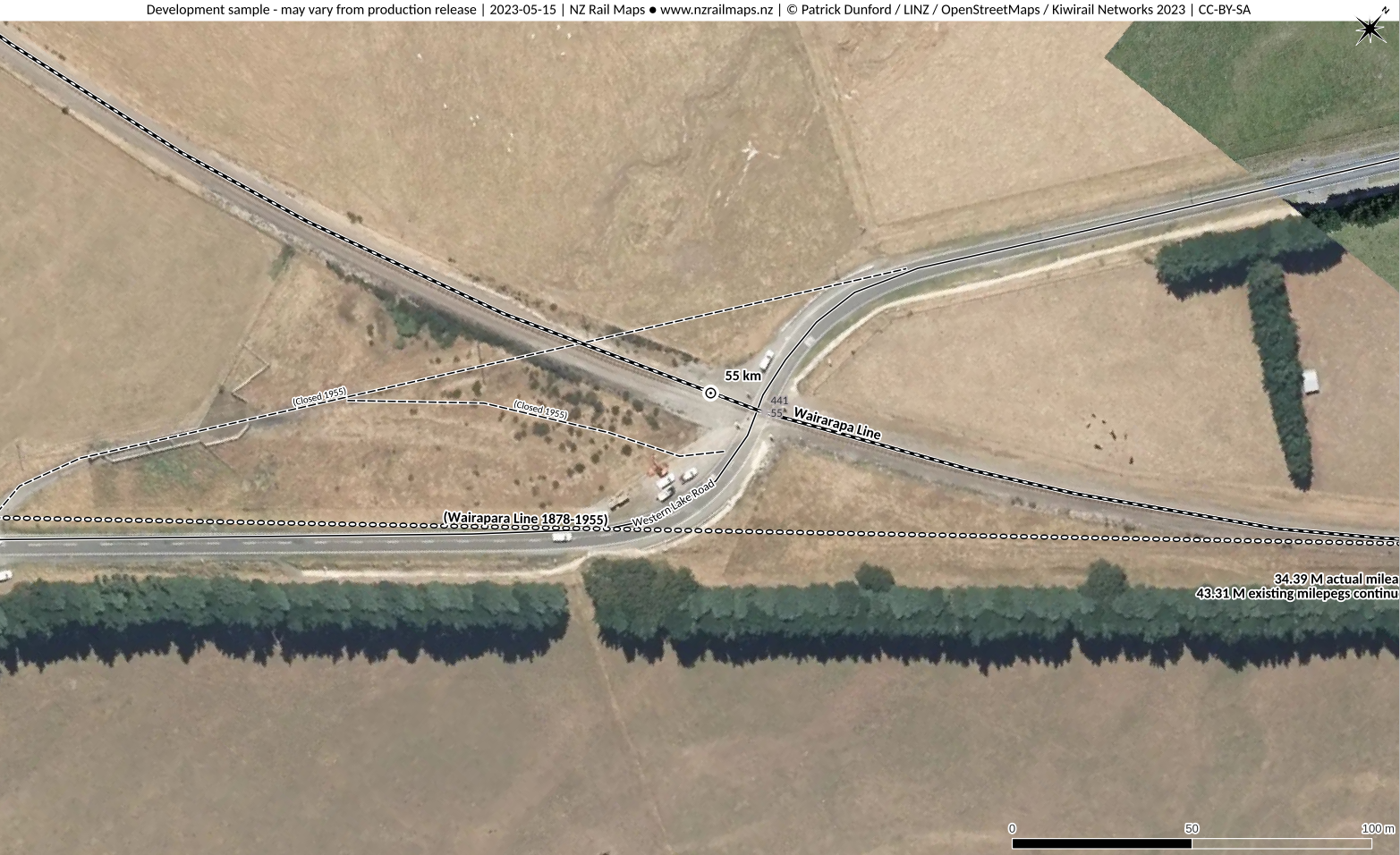
Western Lake Road Featherston (Speedys Crossing)
ALCAM ID
441
Track Distance
55 km
Road Name
Western Lake Road
Nearest Town
Featherston
Lat/Long:
-41.1255,175.3099
Traffic Controls
Stop Signs
Daily Trains
22
Daily Vehicles
530
Road Authority
South Wairarapa District Council
Aerial View
Safety Assessment
This crossing may be dangerous because curves in the rail track could result in a reduction of sight lines for trains approaching from both directions. Multiple serious level crossing accidents have occurred at this crossing but the specific details such as the direction of traffic and trains aren’t completely known at this time.
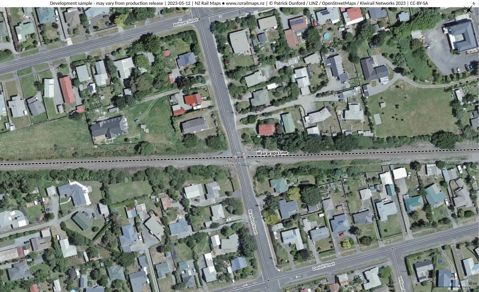
Name
Brandon Street Featherston
ALCAM ID
442
Track Distance
56.24 km
Road Name
Brandon Street
Nearest Town
Featherston
Lat/Long:
-41.1187, 175.3213
Traffic Controls
Flashing Lights
Daily Trains
10
Daily Vehicles
351
Road Authority
South Wairarapa District Council
Aerial View
Safety Assessment
There are no apparent design issues around this crossing.
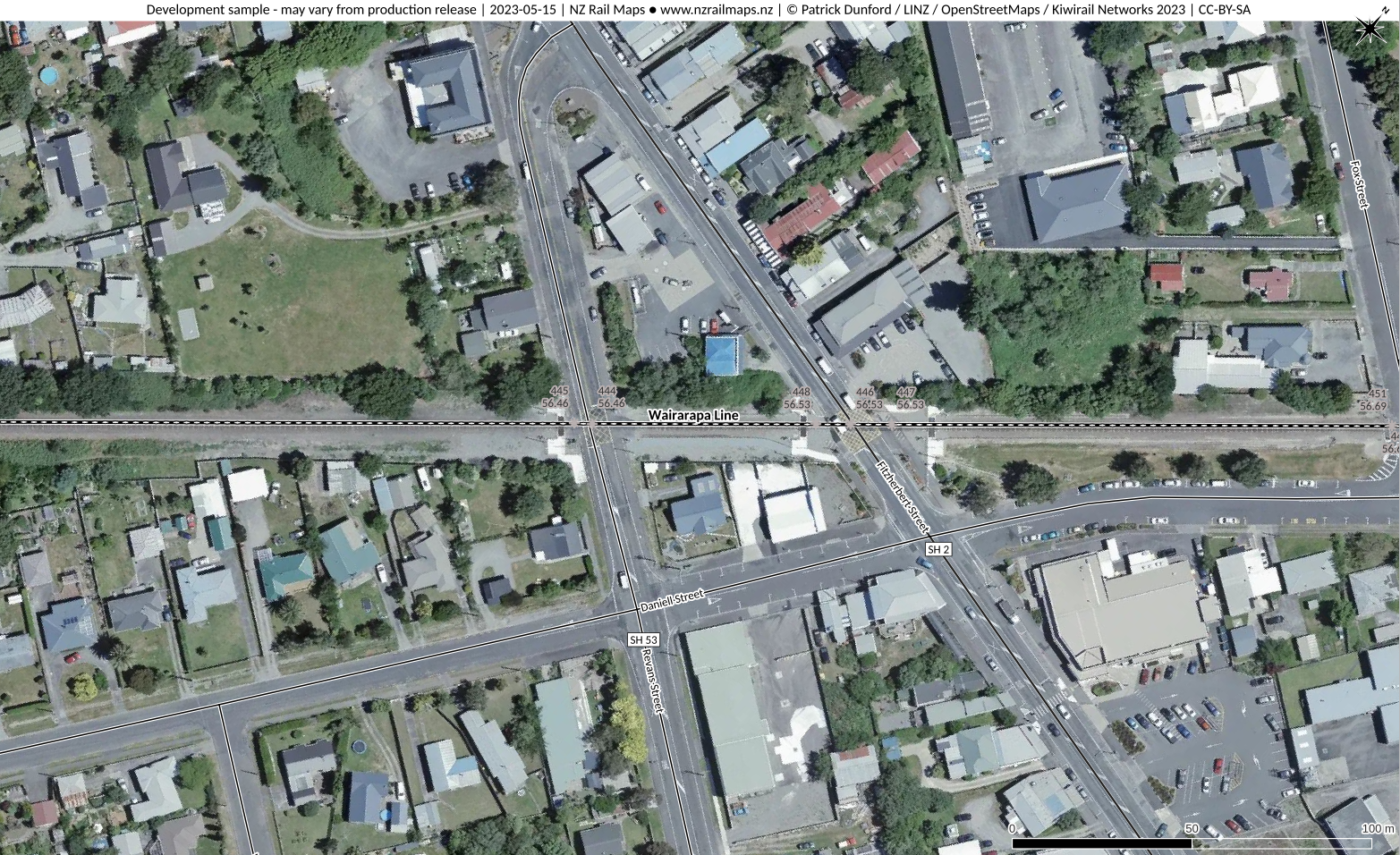
Name
SH53 Revans Street Featherston
ALCAM ID
444
Track Distance
56.46 km
Road Name
SH53
Nearest Town
Featherston
Lat/Long:
-41.1174, 175.3234
Traffic Controls
Barrier Arms
Daily Trains
13
Daily Vehicles
2275
Road Authority
NZTA
Aerial View
Safety Assessment
Risk exists of overshoot of the crossing due to driver distraction from right turning maneuvers at the adjacent Daniell Street intersection. Close proximity to the SH2 crossing suggests one of the crossings should be considered for closure by shifting the junction of SH53.
Name
SH2 Fitzherbert Street Featherston
ALCAM ID
446
Track Distance
56.53 km
Road Name
SH2
Nearest Town
Featherston
Lat/Long:
-41.117, 175.3241
Traffic Controls
Barrier Arms
Daily Trains
13
Daily Vehicles
8306
Road Authority
NZTA
Aerial View
Safety Assessment
Risk exists of overshoot of the crossing due to driver distraction from right turning maneuvers at the adjacent Daniell Street intersection. There is also the question of whether sufficient stacking clearance is achieved from the same intersection. Close proximity to the SH53 crossing suggests one of the crossings should be considered for closure by shifting the junction of SH53. This chould be done in conjunction with improved traffic safety at SH2/SH53 road junction, i.e. a roundabout or traffic lights.
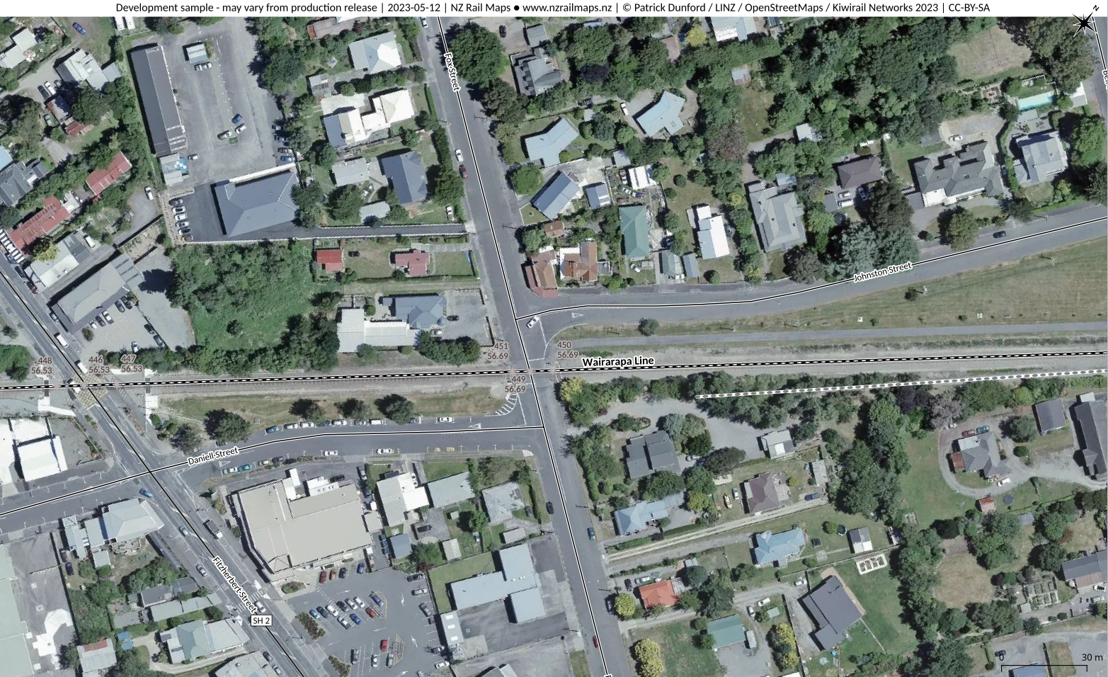
Name
Fox Street Featherston
ALCAM ID
449
Track Distance
56.69 km
Road Name
Fox Street
Nearest Town
Featherston
Lat/Long:
-41.1161, 175.3255
Traffic Controls
Flashing Lights
Daily Trains
10
Daily Vehicles
571
Road Authority
South Wairarapa District Council
Aerial View
Safety Assessment
The crossing is dangerous because it has two adjacent road T intersections. These intersections create insufficient stacking clearance for long road vehicles to be clear of both the railway and the intersection in both directions.
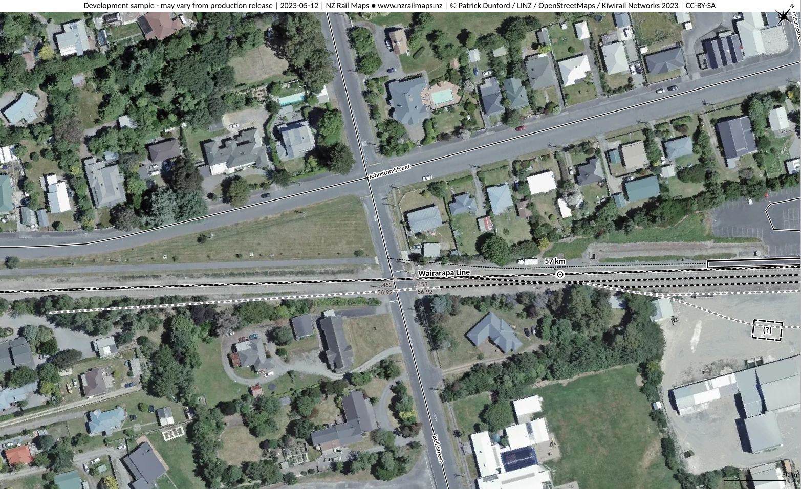
Name
Bell Street Featherston
ALCAM ID
452
Track Distance
56.92 km
Road Name
Bell Street
Nearest Town
Featherston
Lat/Long:
-41.1148, 175.3276
Traffic Controls
Flashing Lights
Daily Trains
9
Daily Vehicles
594
Road Authority
South Wairarapa District Council
Aerial View
Safety Assessment
The distance between the crossing and Johnston Street might be insufficient to achieve stacking clearance for long commercial vehicles. Risk exists of overshooting the crossing when performing right turning maneuvers towards the crossing from the Johnston Street intersection.
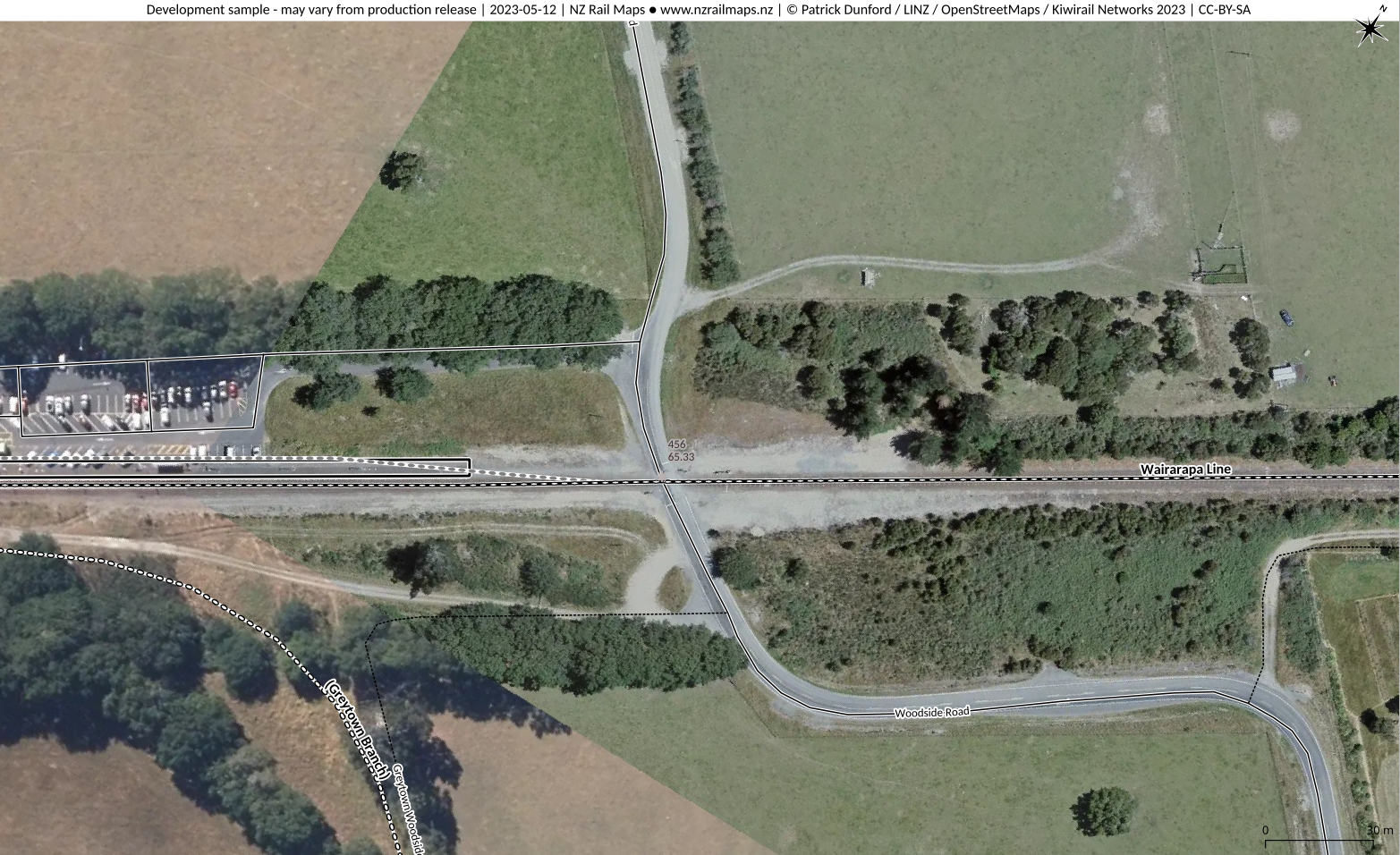
Name
Woodside Road Woodside
ALCAM ID
456
Track Distance
65.33
Road Name
Woodside Road
Nearest Town
Greytown
Lat/Long:
-41.0665, 175.4036
Traffic Controls
Flashing Lights
Daily Trains
10
Daily Vehicles
585
Road Authority
South Wairarapa District Council
Aerial View
Safety Assessment
There are no apparent design issues affecting safety at this crossing.
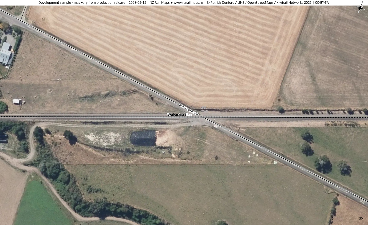
Name
Matarawa Road Matarawa
ALCAM ID
454
Track Distance
67.52 km
Road Name
Matarawa Road
Nearest Town
Greytown
Lat/Long:
-41.0556, 175.425
Traffic Controls
Stop Signs
Daily Trains
13
Daily Vehicles
70
Road Authority
Carterton District Council
Aerial View
Safety Assessment
This crossing is dangerous because of the severe skewed alignment of the road over the crossing. This makes it very difficult for people to see approaching trains from all directions when stopped at the crossing. Due to the low traffic volume the Council should alter the crossing to place that section of road at right angles to the track, or if appropriate, the crossing and road past the crossing should become private.
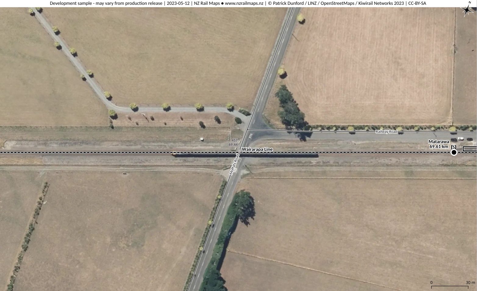
Name
Moffats Road Matarawa
ALCAM ID
457
Track Distance
69.44 km
Road Name
Moffatts Road
Nearest Town
Greytown
Lat/Long:
-41.0495, 175.4463
Traffic Controls
Stop Signs
Daily Trains
14
Daily Vehicles
120
Road Authority
Carterton District Council
Aerial View
Safety Assessment
Due to the adjacent intersection of Railway Road there is insufficient stacking clearance for vehicles between the intersection and crossing.
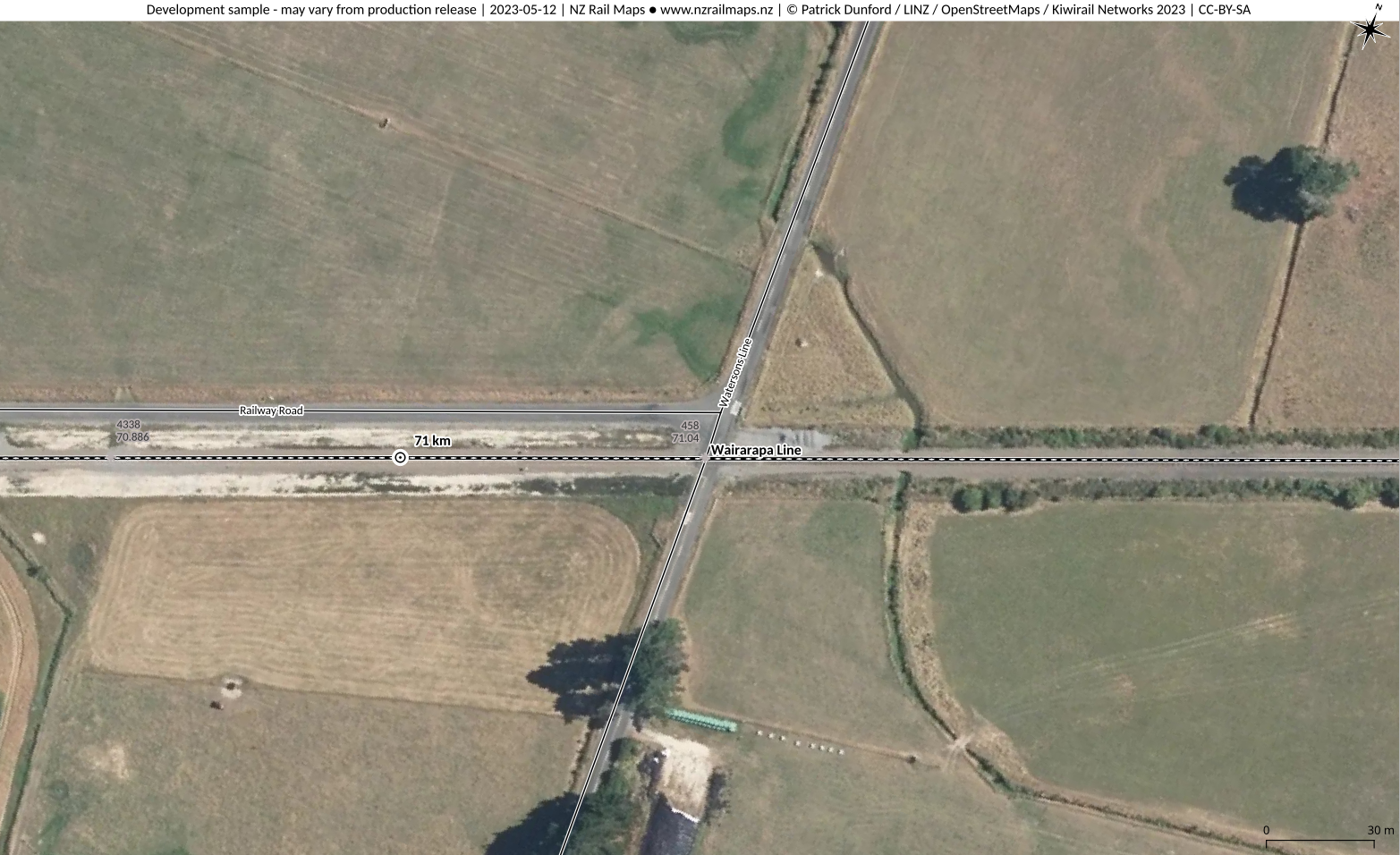
Name
Watersons Line Matarawa
ALCAM ID
458
Track Distance
71.04 km
Road Name
Watersons Line
Nearest Town
Greytown
Lat/Long:
-41.044, 175.4564
Traffic Controls
Stop Signs
Daily Trains
14
Daily Vehicles
54
Road Authority
Carterton District Council
Aerial View
Safety Assessment
Due to the adjacent intersection of Railway Road there is insufficient stacking clearance for vehicles between the intersection and crossing. Safety risk of overshoot exists for any right turning maneuver from the adjacent intersection that exits over the crossing. Due to the small traffic volume, the council should consider closing this crossing and improve the intersection at the other end of Railway Road.
Name
Hodders Road Matarawa
ALCAM ID
459
Track Distance
73.25 km
Road Name
Hodders Road
Nearest Town
Greytown
Lat/Long:
-41.0369, 175.49
Traffic Controls
Stop Signs
Daily Trains
14
Daily Vehicles
61
Road Authority
Carterton District Council
Aerial View
Safety Assessment
A significant sight line problem exists at this crossing due to the skew angle of the road. This creates a major safety risk for road user who could have difficulty seeing approaching trains from all directions when stopped at the crossing. Given the low traffic volume and lack of alternative access the only reasonable solution is for the council to upgrade the road crossing to place road and rail at right angles to improve the sight lines. Making the crossing and road beyond the crossing private is another option if appropriate.
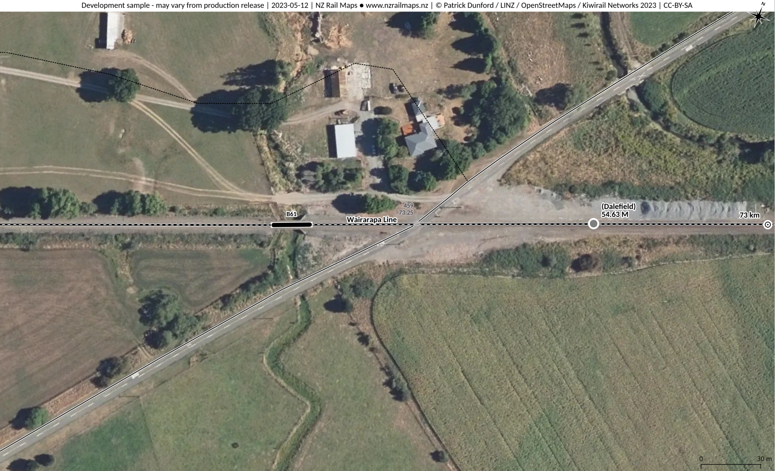
Name
Dalefield Road Carterton
ALCAM ID
460
Track Distance
73.62 km
Road Name
Dalefield Road
Nearest Town
Carterton
Lat/Long:
-41.0358, 175.494
Traffic Controls
Flashing Lights
Daily Trains
10
Daily Vehicles
380
Road Authority
Carterton District Council
Aerial View
Safety Assessment
Given the traffic controls provided there are no obvious design issues affecting safety at this crossing.
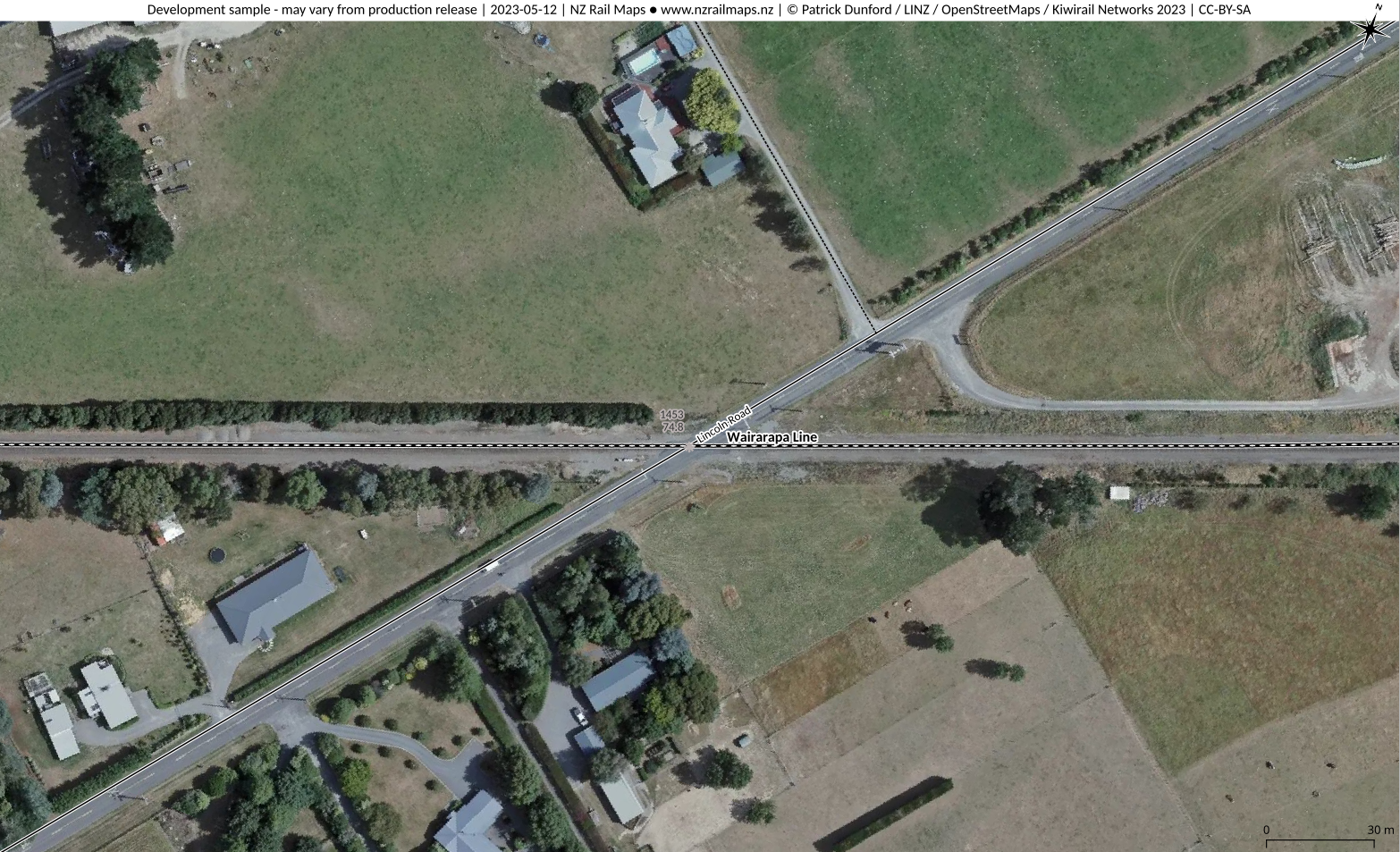
Name
Lincoln Road Carterton
ALCAM ID
1453
Track Distance
74.8 km
Road Name
Lincoln Road
Nearest Town
Carterton
Lat/Long:
-41.032, 175.5072
Traffic Controls
Flashing Lights
Daily Trains
10
Daily Vehicles
1267
Road Authority
Carterton District Council
Aerial View
Safety Assessment
Given the traffic controls provided there are no obvious design issues affecting safety at this crossing.
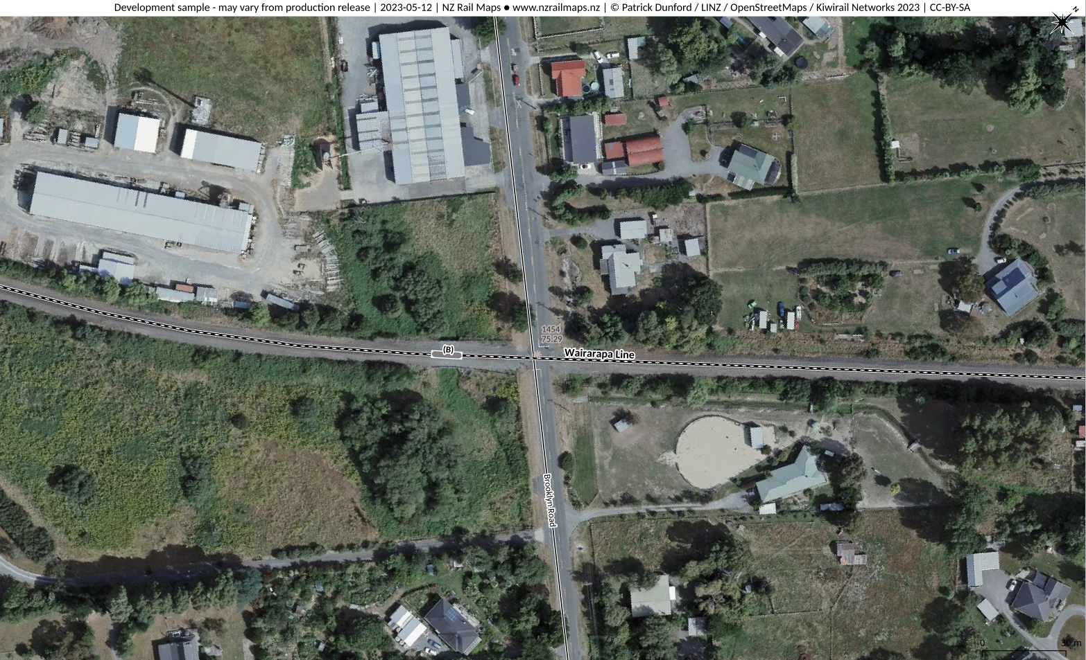
Name
Brooklyn Road Carterton
ALCAM ID
1454
Track Distance
75.29 km
Road Name
Brooklyn Road
Nearest Town
Carterton
Lat/Long:
-41.0299, 175.512
Traffic Controls
Flashing Lights
Daily Trains
10
Daily Vehicles
467
Road Authority
Carterton District Council
Aerial View
Safety Assessment
Given the traffic controls provided there are no obvious design issues affecting safety at this crossing.
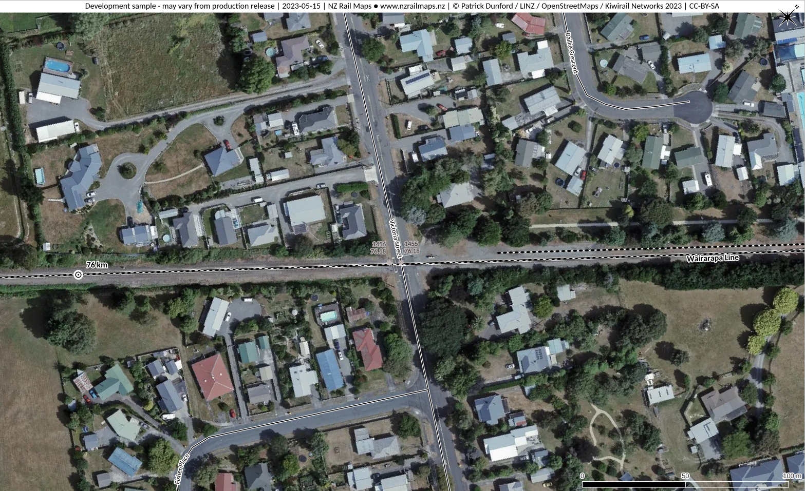
Name
Victoria Street Carterton
ALCAM ID
1455
Track Distance
76.18 km
Road Name
Victoria Street
Nearest Town
Carterton
Lat/Long:
-41.0243, 175.5198
Traffic Controls
Flashing Lights
Daily Trains
10
Daily Vehicles
570
Road Authority
Carterton District Council
Aerial View
Safety Assessment
There are no obvious design issues affecting safety at this crossing.
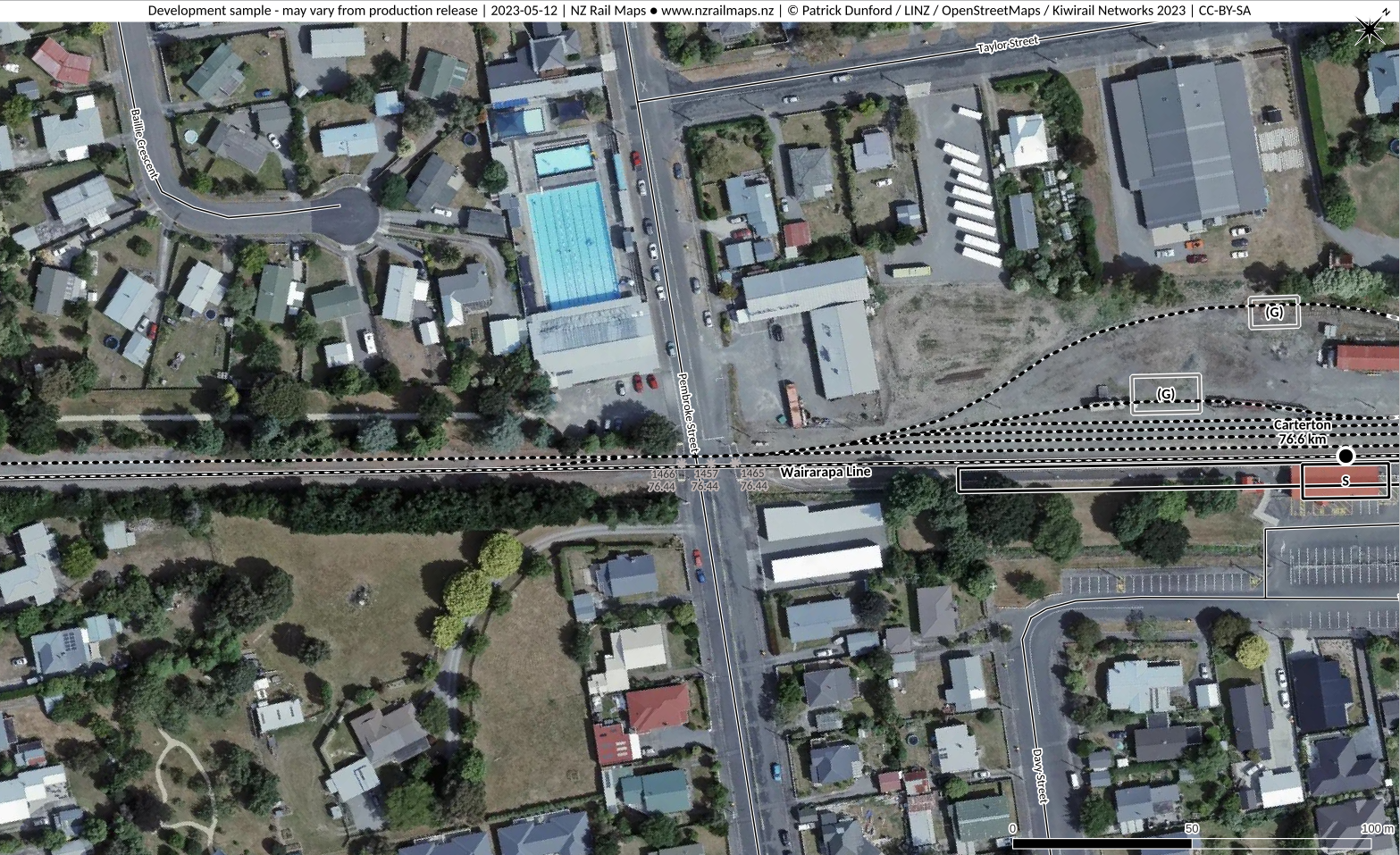
Name
Pembroke Street Carterton
ALCAM ID
1457
Track Distance
76.44 km
Road Name
Pembroke Street
Nearest Town
Carterton
Lat/Long:
-41.0228, 175.5219
Traffic Controls
Flashing Lights
Daily Trains
10
Daily Vehicles
1693
Road Authority
Carterton District Council
Aerial View
Safety Assessment
A safety risk exists with the second track on the crossing as the train at the platform would block visibility of trains using the second track. This could be overcome by upgrading the warning devices at the crossing. A safety risk exists for pedestrians using the footpath into Carterton Station adjacent to the crossing as there is no visual warning device at the crossing facing where this path meets the road. This could be overcome by installing an extra light.
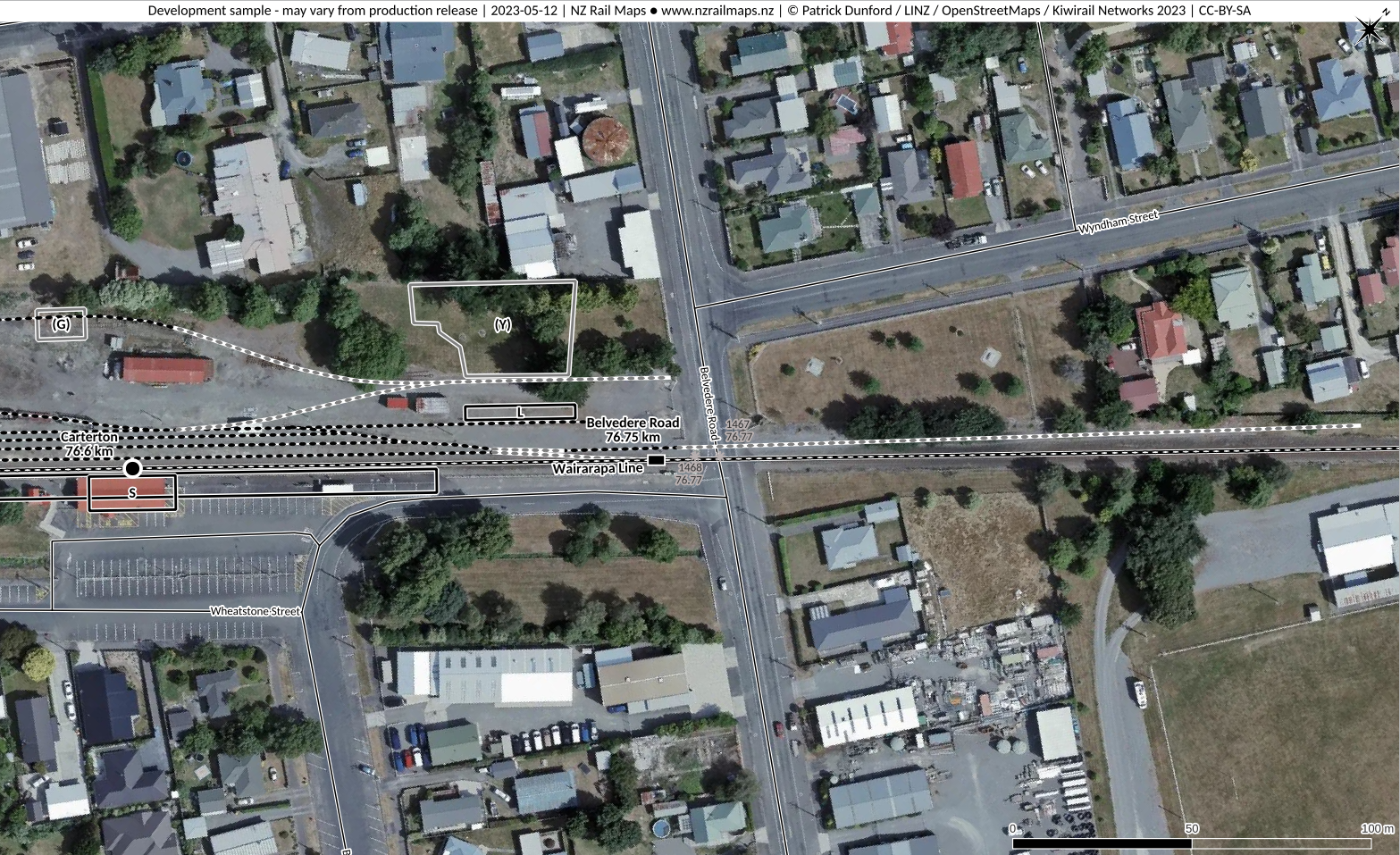
Name
Belvedere Road Carterton
ALCAM ID
1467
Track Distance
76.77 km
Road Name
Belvedere Road
Nearest Town
Carterton
Lat/Long:
-41.0207, 175.5248
Traffic Controls
Flashing Lights
Daily Trains
10
Daily Vehicles
1170
Road Authority
Carterton District Council
Aerial View
Safety Assessment
A safety risk exists with insufficient stacking clearance between the crossing and the adjacent Broadway intersection. There may be a safety risk of insufficient stacking clearance from the Wyndham Road intersection. The best safety solution is to close intersection(s) as road(s) have convenient alternative access nearby.
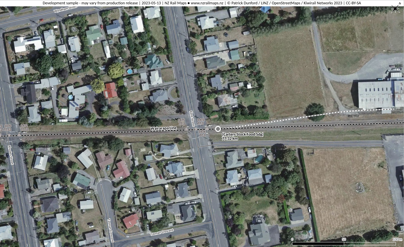
Name
Rhodes Street Carterton
ALCAM ID
1470
Track Distance
77.12 km
Road Name
Rhodes Street
Nearest Town
Carterton
Lat/Long:
-41.0185, 175.5278
Traffic Controls
Flashing Lights
Daily Trains
10
Daily Vehicles
400
Road Authority
Carterton District Council
Aerial View
Safety Assessment
There are no obvious design safety issues affecting this crossing.
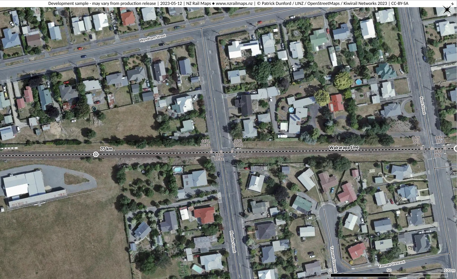
Name
Kent Street Carterton
ALCAM ID
1473
Track Distance
77.3 km
Road Name
Rhodes Street
Nearest Town
Carterton
Lat/Long:
-41.0173, 175.5294
Traffic Controls
Flashing Lights
Daily Trains
10
Daily Vehicles
1600
Road Authority
Carterton District Council
Aerial View
Safety Assessment
Carterton District Council should assess the risk to crossing safety from heavy commercial vehicles entering/exiting the premises of ITM Timspec at 30 Kent St due to close proximity of the crossing and consequent possible stacking clearance issues and impose traffic restrictions if necessary.
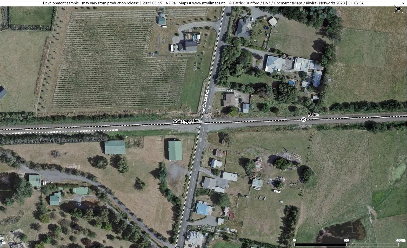
Name
Andersons Line Carterton
ALCAM ID
1476
Track Distance
77.91 km
Road Name
Andersons Line
Nearest Town
Carterton
Lat/Long:
-41.0135, 175.5346
Traffic Controls
Stop Signs
Daily Trains
14
Daily Vehicles
149
Road Authority
Carterton District Council
Aerial View
Safety Assessment
There are no obvious design safety issues at this crossing.
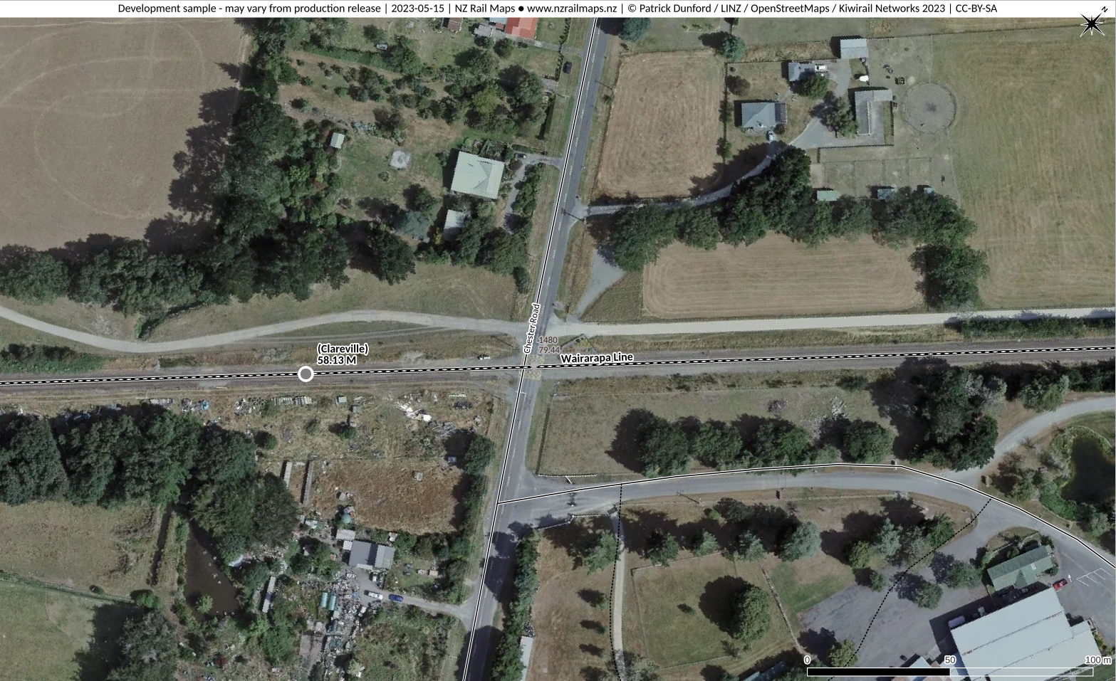
Name
Chester Road Carterton
ALCAM ID
1480
Track Distance
79.44 km
Road Name
Chester Road
Nearest Town
Carterton
Lat/Long:
-41.004, 175.5346
Traffic Controls
Flashing Lights
Daily Trains
14
Daily Vehicles
149
Road Authority
Carterton District Council
Aerial View
Safety Assessment
The entrance to the Wairarapa A&P Showgrounds may be close enough to the crossing to create stacking clearance issues for heavy commercial vehicles. The risk of this should be assessed by Carterton District Council and if necessary traffic restrictions imposed. Two private roads form an effective four way intersection close to the northern approach onto the crossing. Carterton District Council should assess the risk of stacking clearance issues for heavy commercial vehicles entering or exiting these roads and if necessary impose traffic restrictions.
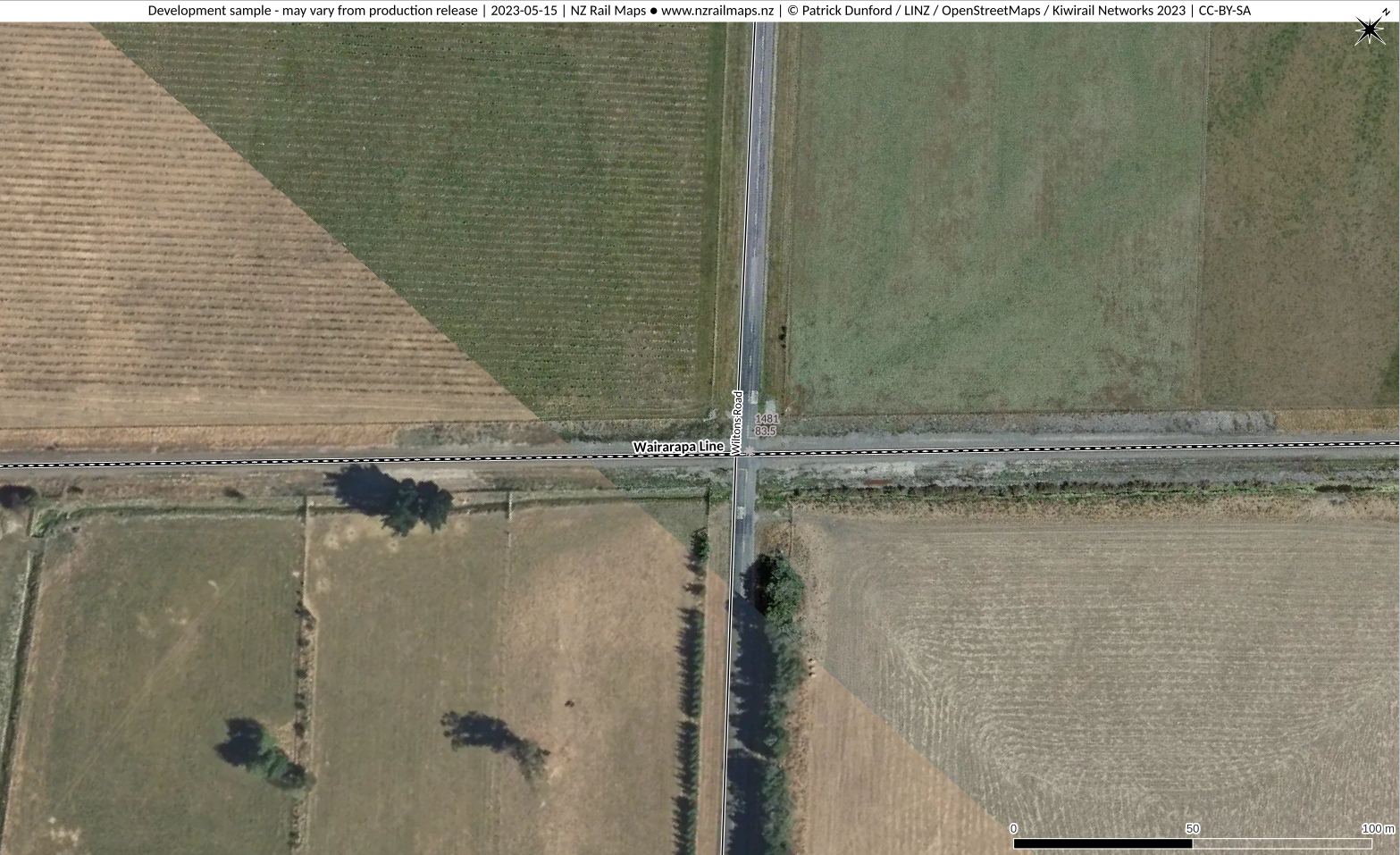
Name
Wiltons Road Waingawa
ALCAM ID
1481
Track Distance
83.5 km
Road Name
Wiltons Road
Nearest Town
Carterton
Lat/Long:
-40.9787, 175.5825
Traffic Controls
Stop Signs
Daily Trains
10
Daily Vehicles
150
Road Authority
Carterton District Council
Aerial View
Safety Assessment
There are no obvious design safety issues at this crossing.
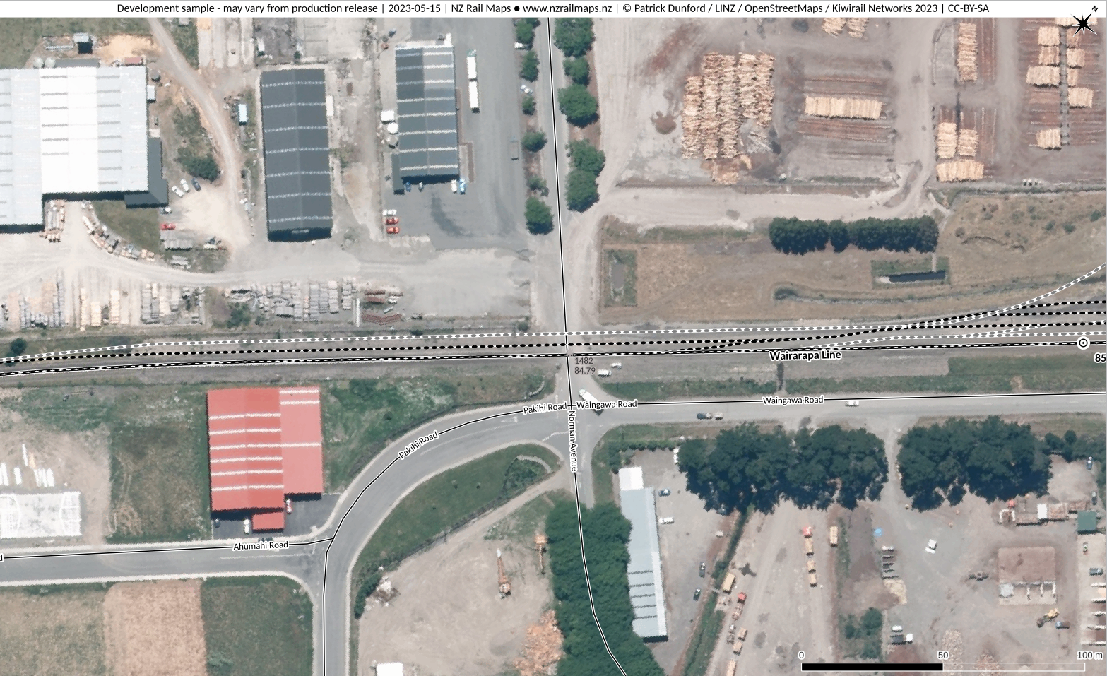
Name
Norman Avenue Waingawa
ALCAM ID
1482
Track Distance
84.79 km
Road Name
Norman Avenue
Nearest Town
Masterton
Lat/Long:
-40.9787, 175.5825
Traffic Controls
Barrier Arms
Daily Trains
10
Daily Vehicles
870
Road Authority
Carterton District Council
Aerial View
Safety Assessment
This crossing has existing insufficient stacking clearance for heavy commercial vehicles dating from its historical T intersection state. This was exacerbated with the effective extension of Waingawa Road into Pahiki Road during development of the industrial park on the south side, making the intersection four way. Transit NZ sought to have Norman Avenue closed at its junction with SH2 at that time, which would have alleviated some of the safety problems from the intersection. Another risk is from overshoot of the crossing by vehicles making a right turn from Waingawa Road. There was a level crossing collision here in 2017 involving a heavy commercial vehicle. This resulted in Kiwirail upgrading the traffic controls to barrier arms in 2019. Carterton District Council temporarily closed the SH2 / Norman Avenue intersection also in 2019; this increased the incidence of right turns required to access the Normans Road crossing thus increasing the risk of crossing overshoots. The proposed permanent change to the SH2 intersection would allow the road to continue to be used for heavy traffic and has not in any way considered the safety risks at the crossing. Carterton District Council should consider closing the Normans Avenue crossing and forming road access into the area from Norfolk Road.
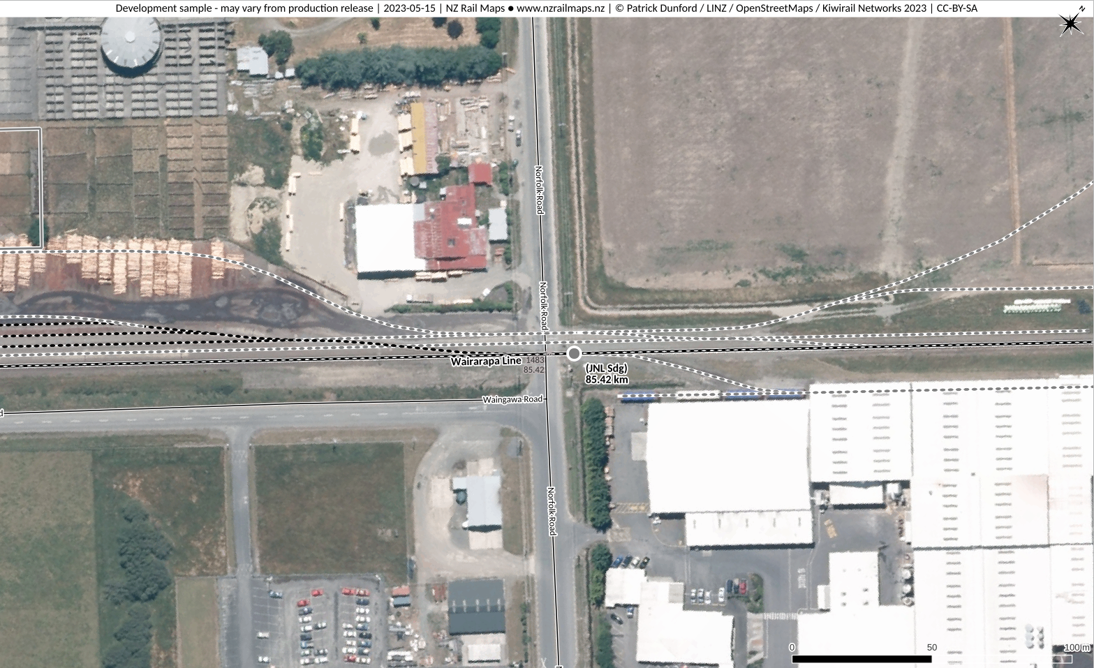
Name
Norfolk Road Waingawa
ALCAM ID
1483
Track Distance
85.42 km
Road Name
Norfolk Road
Nearest Town
Masterton
Lat/Long:
-40.9672, 175.5994
Traffic Controls
Flashing Lights
Daily Trains
14
Daily Vehicles
1446
Road Authority
Carterton District Council
Aerial View
Safety Assessment
There is insufficient stacking clearance from the T intersection of Waingawa Road south of this crossing, and from the log loading yard exit north of the crossing. Also see comments about Norman Avenue Crossing.
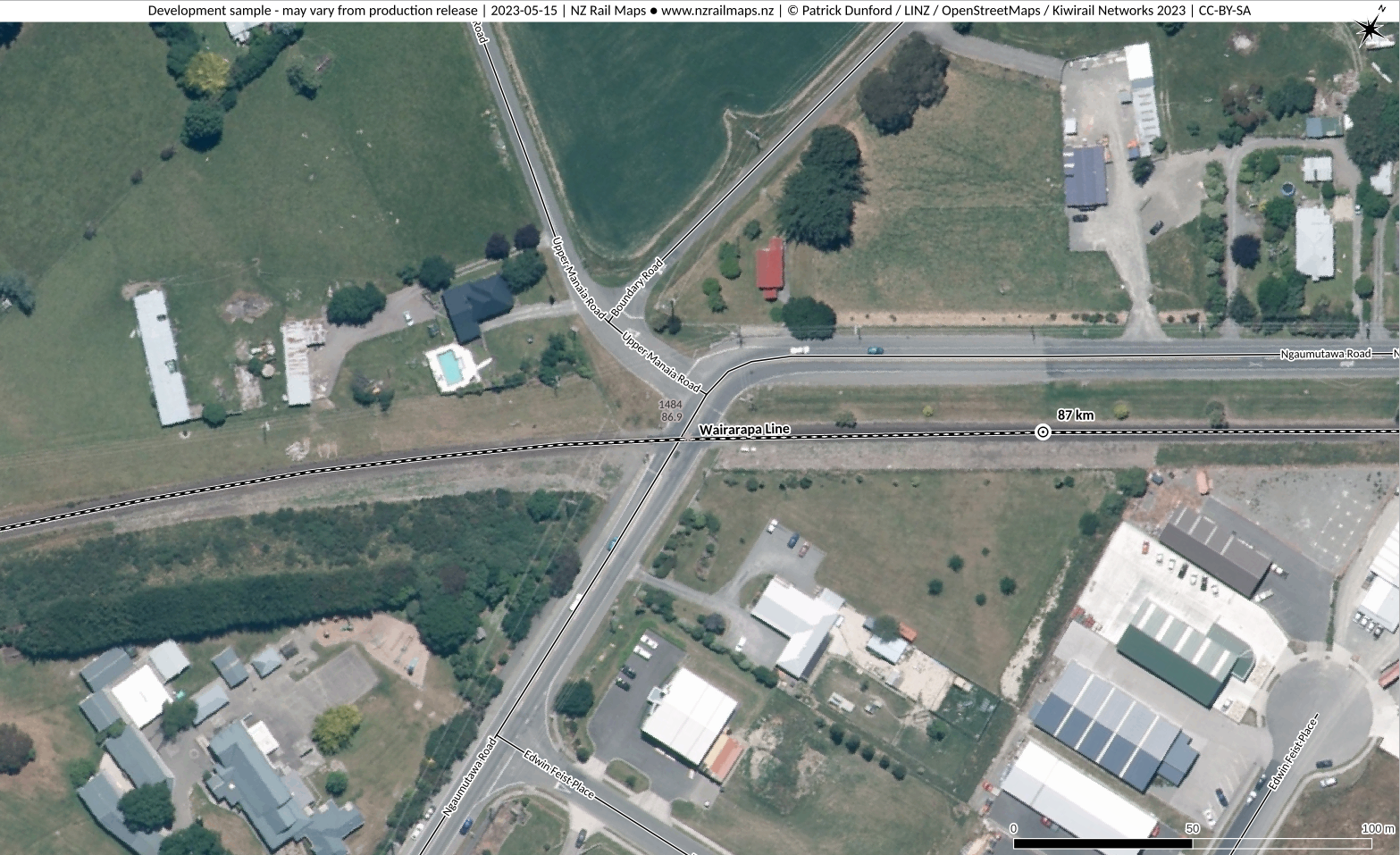
Name
Ngaumutawa Road Solway
ALCAM ID
1484
Track Distance
86.9 km
Road Name
Ngaumutawa Road
Nearest Town
Masterton
Lat/Long:
-40.9589, 175.6131
Traffic Controls
Barrier Arms
Daily Trains
9
Daily Vehicles
3600
Road Authority
Masterton District Council
Aerial View
Safety Assessment
Insufficient stacking clearance is a hazard due to the close proximity of the intersection with Upper Manaia Road.
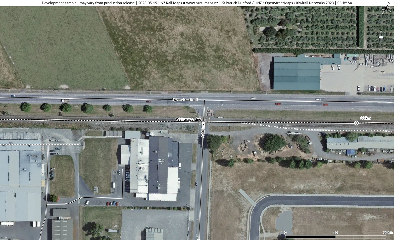
Name
Judds Road Solway
ALCAM ID
1485
Track Distance
87.85 km
Road Name
Judds Road
Nearest Town
Masterton
Lat/Long:
-40.9545, 175.6229
Traffic Controls
Flashing Lights
Daily Trains
12
Daily Vehicles
892
Road Authority
Masterton District Council
Aerial View
Safety Assessment
Insufficient stacking clearance at the north side is a safety hazard. Commercial premises entrances on the south side should be assessed by Masterton District Council and traffic restrictions imposed if necessary.
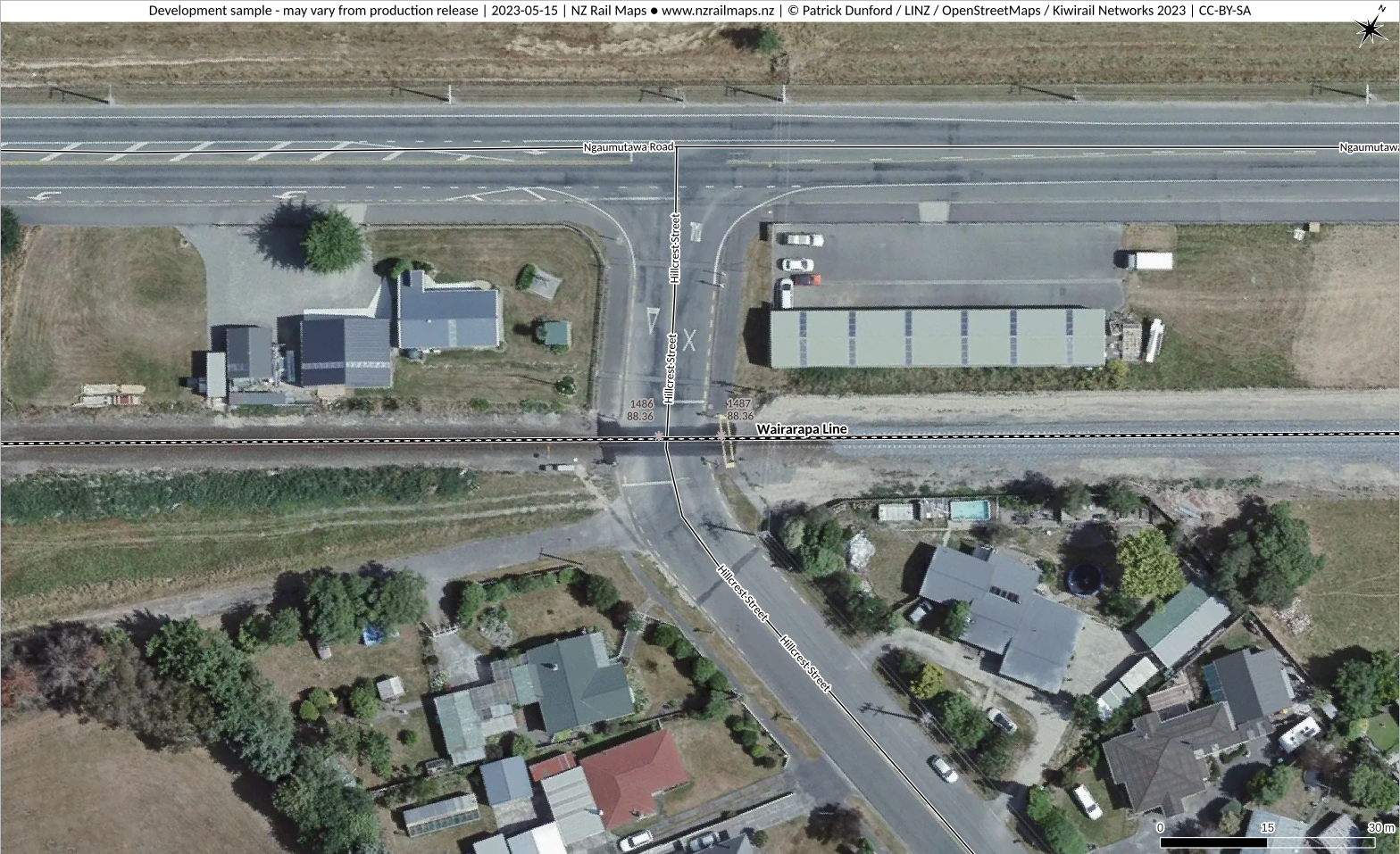
Name
Hillcrest Street Solway
ALCAM ID
1486
Track Distance
88.36 km
Road Name
Hillcrest Street
Nearest Town
Masterton
Lat/Long:
-40.9522, 175.6281
Traffic Controls
Flashing Lights
Daily Trains
12
Daily Vehicles
1175
Road Authority
Masterton District Council
Aerial View
Safety Assessment
Need confirmation that safe stacking clearance is achieved. Private road on the south side is too close to the crossing and creates safety risks especially with heavy commercial vehicles.
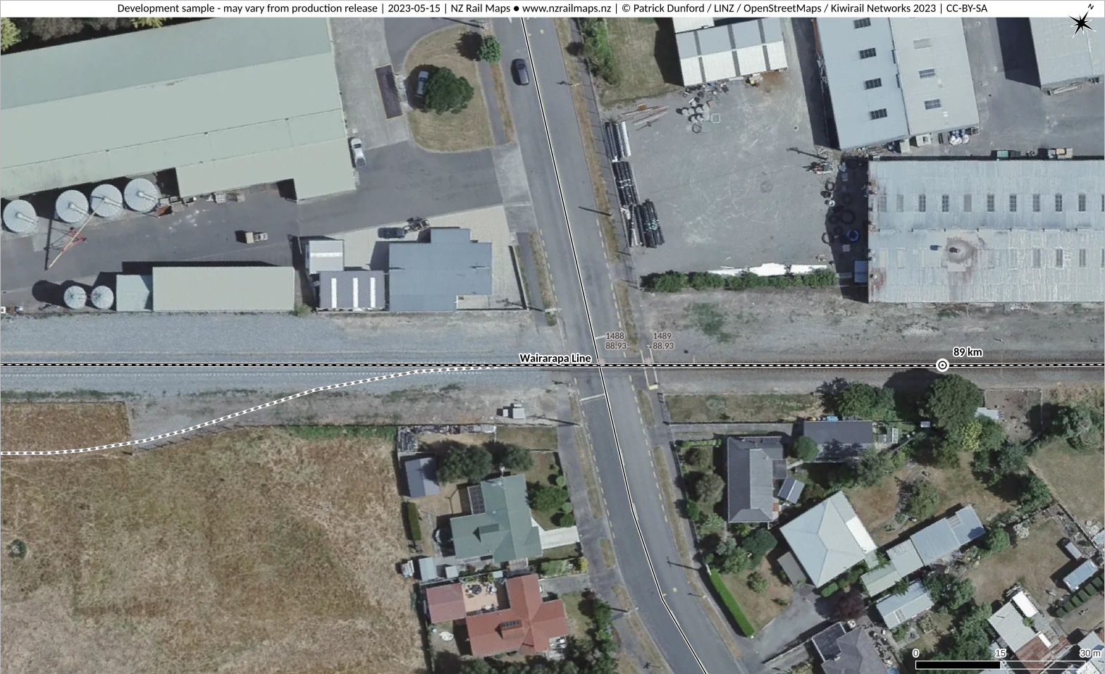
Name
Cornwall Street Masterton
ALCAM ID
1488
Track Distance
88.93 km
Road Name
Cornwall Street
Nearest Town
Masterton
Lat/Long:
-40.9497, 175.6339
Traffic Controls
Flashing Lights
Daily Trains
10
Daily Vehicles
846
Road Authority
Masterton District Council
Aerial View
Safety Assessment
Uncertain if commercial premises entrance on north side allows sufficient stacking clearance.
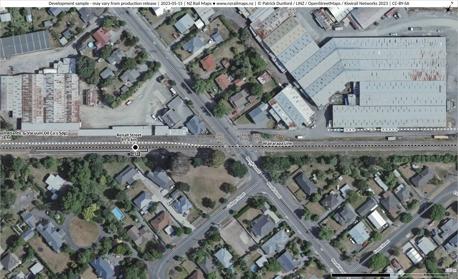
Name
Renall Street Masterton
ALCAM ID
1490
Track Distance
89.49 km
Road Name
Renall Street
Nearest Town
Masterton
Lat/Long:
-40.9471, 175.6397
Traffic Controls
Flashing Lights
Daily Trains
10
Daily Vehicles
4273
Road Authority
Masterton District Council
Aerial View
Safety Assessment
Need confirmation that safe stacking clearance is achieved from the intersection of College Street at the south side of the crossing. Unauthorised access into the rail corridor possibility on the north-west side and commercial premises entrance on the north-east side create possible additional risks; Masterton District Council should assess the risk of HCVs accessing the commercial premises and if necessary impose traffic restrictions.
Name
Akura Road Masterton
ALCAM ID
1493
Track Distance
91.16 km
Road Name
Akura Road
Nearest Town
Masterton
Lat/Long:
-40.9471, 175.6397
Traffic Controls
Flashing Lights
Daily Trains
10
Daily Vehicles
4423
Road Authority
Masterton District Council
Aerial View
Safety Assessment
Assurance is needed that the commercial premises entrance on the north-east side of the crossing is not too close to the crossing.